Grade
5
Math in Our World: Hiking Wells Reserve
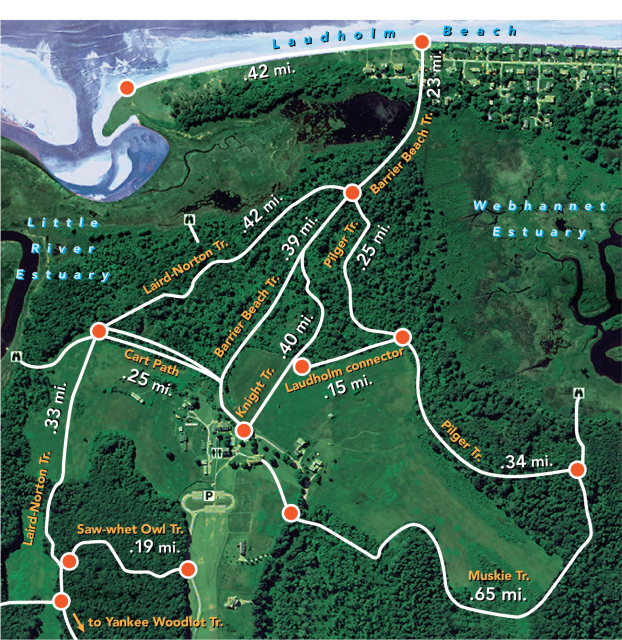
In our family, we hike a lot. One of the places we like to hike is called the Wells Reserve. It has trails through the woods, on boardwalks, and down to the beach.
If we don’t have much time, we hike straight down the Barrier Beach Trail to Laudholm Beach, and then come back. But sometimes we wander around on longer hikes.
- Use pictures, models, or numbers to show what is happening.
- What do you notice? What do you wonder?
- What mathematical questions can you ask about this situation? Answer any questions you can!
- Choose one or more trails someone could hike on. Draw a number line to represent their lengths.
- If you wanted to walk about 2 ½ miles, what is a route you could take? How long is your route?
- When adding decimals, you can use a lot of the same strategies as when you add whole numbers. Consider using place-value splitting or jumping to friendly numbers.
- Show your work to someone else, and explain your thinking. Did they understand?
- Ask whether they have any other questions you can answer!
- Use the labeled distances on the map to estimate other, unlabeled distances on the map For example, the length of the Little River Estuary, the distances to the overlooks (shown with binoculars), the length of the road at the top of the map, or others.
- Work with your family to plan a hike near you. Follow all the rules of the trails and be safe.
Printable Version
Google doc for printing and copying
Reference for Educators
Sample problems and solutions